Aerial surveying
Aerial Surveying
Using XMission, our team is able to provide centimeter level precision aerial mapping with high-resolution RGB and multi-spectral cameras. As a result, our services include aerial orthographic mapping, digital surface model mapping, precision control mapping, multispectral mapping and aerial photography.

These services are invaluable when identifying issues you might not even be aware of. For example, our high resolution maps provide advanced details of your property, saving you time and money and monitoring events such as crop stress. In addition, having a birds-eye view of your land will afford you greater insight into how to better utilize your land, make highly informed decisions when you sow and spray your crops.

Precision Contour Mapping
Water management on farms requires accurate measurements for efficient diversion of water flows and building of precision irrigation systems. In short, autonomous drones can fly over large areas with centimeter level precision in both the vertical and horizontal dimensions. As a result, the contour maps can be displayed by individual contours at any spacing or as a banded color visual between contours.

Aerial Orthographic Mapping
An orthophoto, orthophotograph or orthoimage is an aerial photograph geometrically corrected (“orthorectified”) to fit the scale of a satellite imaging map. Furthermore, orthophotographs can be used to measure true distances, because they are an accurate representation of the Earth’s surface, having been adjusted for topographic relief, lens distortion, and camera tilt.

Digital Surface Model Mapping
This picture of a research field of wheat is a digital surface model and represents the earth’s surface and includes all objects on it. To sum up, this can then be used for various analysis. For example, determining the height of the vegetation by measuring the variation in height across a grass paddock, or the roughness of a wheat crop surface, or difference in growth rates between crop varieties.

Multispectral Mapping for Crops
Light of different wavelengths reflects from crops and can be measured to determine the nature of the surface. Hence, vegetation can be distinguished from the ground. Furthermore, depending on the plant and it’s state, different leaves can reflect differently at different wavelengths.
Hyperspectral detection can measure hundreds of specific wavelengths between 350-750 nm and multispectral cameras measure 4 or 5 bands. As a result, in the picture red is the ground and different shades of green represent wheat crop vegetation.
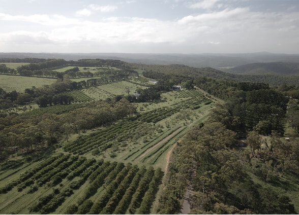
Aerial Photography of Property
RGB cameras can be used to get aerial views of property, plants and animals which can be used as a normal record of a place or an event or the consequence of say a weather event. Furthermore, they can also be used to count vegetation or to get 3D reconstructions of the property.

Drone Inspections of Property
Drones can be used to inspect and analyze a wide range of objects. These include on farm water structures, wind turbine generator blades, solar panels, power-lines and towers.

XMission is an industrial level surveying drone which can be equipped with two cameras. Firstly, the XCAM RGB which captures high resolution images of landscapes (1 cm/pixel). Second, the multi-spectral camera which can capture numerous spectral bands including green, red, red edge, and near infrared.
This versatile, state-of-the-art model is invaluable for capturing outstanding images which can be processed through XAG Cloud or third-party data processing tools to generate NDVI and other index maps and ensure extreme data accuracy.